Anatomy of Warm and Cold Fronts

|
|
Warm Fronts:
As the illustration shows, when a warm front travels towards cold air, the warm air (which has expanded) travels up over the cold front, toppling over itself, creating different types of stratus and cirrus clouds as its elevation changes. Often stratus clouds are associated with warm fronts. This means that clouds can be visible days before the warm temperatures from the front appear. Once a front passes, the temperature increases behind where the front was. If someone were to stand further away from the oncoming front, they would still see clouds, but they would be much higher up (cirrus) than right where the fronts meet. This is because the warm front is traveling up over the cold front. Stratus clouds are precipitation clouds, so a warm front meeting a cold front often creates rain. Even cirrus clouds are precipitation clouds, but they are so high up in the air that their precipitate never reaches the earth.
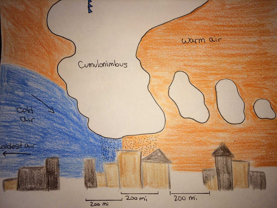
Cold Fronts:
Cold fronts are different than warm fronts because the cold air from the front, sneaks under the warm air it is meeting, creating cumulonimbus clouds a.k.a. thunderclouds (which bring downpours). Much like the warm front, the temperatures of the cold front don't occur once clouds are visible, and often not while it is raining either, because the cold air comes from behind the front (often when the sky is clear). After the clouds and rain have passed, the cold temperatures from the front begin to occur.
Inversions:
Inversions happen when a cold front gets pushed over a warm front and sits there, because the cold air is too dense to go any higher. This causes the warm air, below the cold air, to spread out under the cold air and create a layer. Pollution from cities below this, rise up and get caught in the warm layer of air, creating a smog.
As the illustration shows, when a warm front travels towards cold air, the warm air (which has expanded) travels up over the cold front, toppling over itself, creating different types of stratus and cirrus clouds as its elevation changes. Often stratus clouds are associated with warm fronts. This means that clouds can be visible days before the warm temperatures from the front appear. Once a front passes, the temperature increases behind where the front was. If someone were to stand further away from the oncoming front, they would still see clouds, but they would be much higher up (cirrus) than right where the fronts meet. This is because the warm front is traveling up over the cold front. Stratus clouds are precipitation clouds, so a warm front meeting a cold front often creates rain. Even cirrus clouds are precipitation clouds, but they are so high up in the air that their precipitate never reaches the earth.
Cold Fronts:
Cold fronts are different than warm fronts because the cold air from the front, sneaks under the warm air it is meeting, creating cumulonimbus clouds a.k.a. thunderclouds (which bring downpours). Much like the warm front, the temperatures of the cold front don't occur once clouds are visible, and often not while it is raining either, because the cold air comes from behind the front (often when the sky is clear). After the clouds and rain have passed, the cold temperatures from the front begin to occur.
Inversions:
Inversions happen when a cold front gets pushed over a warm front and sits there, because the cold air is too dense to go any higher. This causes the warm air, below the cold air, to spread out under the cold air and create a layer. Pollution from cities below this, rise up and get caught in the warm layer of air, creating a smog.
