Tornado Structure
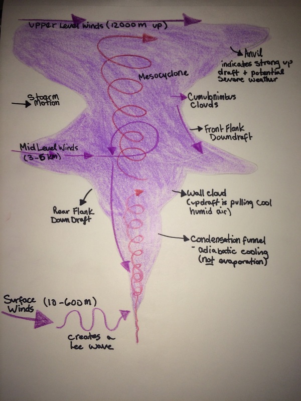
Tornadoes form when different air masses collide, with contrasting wind speeds and temperatures in the top, middle, and lower portion of the atmosphere, creating a vertical swirling motion. This in unlike a hurricane in that it doesn't need to be by a water source, and it does need cold air to work. Another necessity to form a tornado is a supercell, which creates sever cumulonimbus clouds through updraft. This updraft creates a mesocyclone which draws air (mid level winds) through the middle of the vertical swirling, causing it to turn and create horizontal swirling, which is commonly known as a tornado.
Near the ground there is a condensation funnel which consists of warm air. Through adiabatic cooling, cool humid air is sucked up through the the funnel (updraft) where it rises, cools, and condenses.
Surface winds create lee waves from the amount of pressure build up, resulting in waves 10-600 meters off the ground. The formation of a hurricane requires heat and evaporation, creating convection, whereas tornadoes are created by competing air masses which create a vortex that results in a tornado. Hurricanes are formed near the ocean or large bodies of water, and tornadoes usually occur on the continent.
Fujita Tornado Scale
F0 = 65-85 mph "gale"
F1 = 86-110 mph "moderate"
F2 = 111-135 mph "significant"
F3 = 136-165 mph "severe"
F4 = 166-200 mph "devastating"
F5 = >200 mph "incredible"
F0 = 65-85 mph "gale"
F1 = 86-110 mph "moderate"
F2 = 111-135 mph "significant"
F3 = 136-165 mph "severe"
F4 = 166-200 mph "devastating"
F5 = >200 mph "incredible"
"Red sky at night, sailor's delight. Red sky at morning, sailor's take warning."
This phrase has been used for many years by sailors to indicate whether or not a storm is coming. Cirrostratus clouds create "red sky" and can either indicate that a storm is about to come, or that it has just passed. This phrase really only works for sailors on the east coast because their weather comes from the westerlies, and the sun rises in the east. If cumulus cirrostratus clouds appear at night on the east coast, it means that a storm has already passed because the sky must be clear for the sun to shine from the west to the east to light up the clouds in the east. If they appear in the morning, they indicate that a storm is coming because the sun is shining from the east and lighting up oncoming clouds.
This phrase has been used for many years by sailors to indicate whether or not a storm is coming. Cirrostratus clouds create "red sky" and can either indicate that a storm is about to come, or that it has just passed. This phrase really only works for sailors on the east coast because their weather comes from the westerlies, and the sun rises in the east. If cumulus cirrostratus clouds appear at night on the east coast, it means that a storm has already passed because the sky must be clear for the sun to shine from the west to the east to light up the clouds in the east. If they appear in the morning, they indicate that a storm is coming because the sun is shining from the east and lighting up oncoming clouds.
